CTMQ

Destroying the myth that there is nothing to do here

green mountain modern house
  • CTMQ’s Town Guides
    • Town Completion Celebrations
  • Museums
    • Museum Visits
  • Hikes, Bikes, & Paddles
    • CFPA Trails & Blue Trails Challenge
    • State Parks, Reserves, Preserves, Forests, NAPs, WMAs, & Campsites
    • Land Trust Trails
    • Town Trails
    • Audubon, Nature Conservancy, RWA, and US Army Corps of Engineers Trails
    • Highpointing and Peakbagging
    • Cycling, Multi-Use, & Rails-to-Trails Paths
    • Water Trails
  • Food & Drink
    • Best, Historic, & Unique Restaurants & Foods
    • Classic Diners & True Taverns
    • Homemade Ice Cream, Cheese, & Chocolate Trails
    • Breweries, Brewpubs, & Cideries
    • Wineries & Meaderies
    • Distilleries
  • Everything Else
    • National Designations
    • Firsts, Onlies, Oldests, Largests, Longests, Mosts, Smallests, & Bests
    • Geography
    • Animals, Farms, Gardens, Plants, Trees, Rocks, Waterfalls, & Caves
    • Sports, Thrills, Cruises, Trains, Fairs, Parades, & Events
    • Houses, Communities, Urban Legends, Lighthouses, Libraries, Schools, Businesses, & Theaters
    • Towers, Bridges, Forts, Tunnels, Roads, Canals, Dams, Fishways, Airports, & Ferries
    • Religion, Remembrances, Statuary, & Outdoor Art
    • Cultural, Heritage, & Historic Trails
    • CT Books, Movies, People, & Stories
  • Non-CT
    • Travel & Vacations
    • World Soccer Stadium Tour
    • Highpointing & Peakbagging
    • Books & Reading Challenges
    • Oscar Movies Project
  • About
    • FAQ
    • Family
    • Smith-Magenis Syndrome
    • Press
CTMQ > Hikes, Bikes & Paddles > CFPA Hikes > Pachaug Trail Intro

Pachaug Trail Intro

December 16, 2008 by Steve Leave a Comment

Pachaug Trail
25.1 Miles, Voluntown, Sterling, Griswold, & Rhode Island
December 2008 –

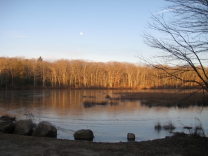
The Pachaug is a mostly flat 25.1 mile horseshoe-shaped trail in the eastern lowlands of Connecticut. It traverses the Pachaug State Forest through Griswold and Voluntown and ventures into Rhode Island for a couple miles as well. Pachaug is a Native American word meaning “turning point of water.” This refers to the winding Pachaug River that the trail follows for a ways… so wait, the name of the river is “turning point of water river?” That hardly makes sense.

Also not making sense is my attempt to solo this and the other three trails that wander through these beautiful pine forests – the Narragansett, Quinebaug, and Nehantic Trails. Yet, I plod onward as my choice of hiking times (sunrise on Sundays) discourages most partners and let’s be honest; I often enjoy the solitude of my journeys.

However, this will make for difficult times on these trails, as they are sort of a crazy spoked wheel, radiating out from Green Pond in Voluntown with plenty of small loops, but extended spokes for miles. As a result, I will need to be a bit creative in my planning and hiking – and ultimately my writing – of these trails.

This should be fun.

Section 1: Route 138/201 Trailhead to southern Quinebaug Crossover Trail
Section 2: To Hell (Hollow) and Back
Section 3: Porter Pond to Green Fall Pond

CFPA Trails Map

Facebooktwitterreddit

Filed Under: CFPA Hikes, Hikes, Bikes & Paddles Tagged With: Blue Trails Challenge, pachaug state forest, Pachaug Trail, Plainfield, Rhode Island, Sterling, Voluntown

Sponsored Links

Leave a Reply

Your email address will not be published. Required fields are marked *

  • Bluesky
  • Email
  • Facebook
  • Goodreads
  • Instagram
  • RSS

Press & Media Inquiries

Latest Museum Visits

The heart of CTMQ

Totally Random Post!

Worthington Pond Farm Covered Bridge

Sponsored Links

Recent Comments

  • Roberta on Camp Aya-Po
  • Emma on East Hartford Nature Park
  • Donna McNally on Nipmuck Trail: Section 3
  • Henry S on URR Trail: Middlefield
  • Mr.Z on Black Hog Brewing Company
Disclaimer
Mission Statement
Copyright © 2025 - CTMQ