
‘I’ Is In The Center of ‘Capital’
151 Farmington Ave, Hartford
May 11, 2008
I promise this will be the only “geographic center of” any of Connecticut’s 169 towns. I had to do one since it’s been impossible getting good data on the geographical center of the state so far. (I’m getting warmer though.) And also because Hartford – or rather the Aetna insurance company – does a cool job of marking the spot.
As is tradition for most families I suspect, this Mother’s Day took us to this important spot in downtown Hartford. While we didn’t see any other families celebrating motherhood at the cool inlaid display on the steps up to the massive brick building, I figured we were just early, that’s all.
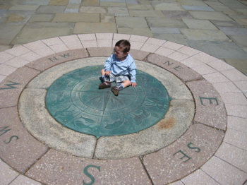
The spot is denoted with a large brass directional compass embedded into the stone. This center of the compass marks the exact geographic center of the city of Hartford.
Cool, right? There’s more! In poking around the Aetna site, I came across this – mere feet from the center:
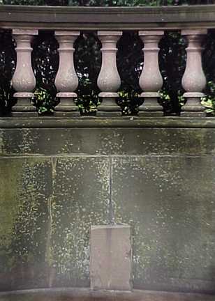
What’s that? Two centuries ago, Farmington Avenue was an unpaved road leading west over Avon Mountain and into the wilds of the Farmington Valley and beyond. The distance traveled was marked in miles by stone pillars, one of which is embedded in the brownstone wall on the west side of the esplanade. Over the years, the markings on this pillar have become faint, but the inscription reads “H 1m.” — the distance from the Old State House to this point is exactly one mile.
Furthermore, the Aetna building is also the World’s Largest colonial building! which is pretty incredible.
![]()
CTMQ’s Geographic Extremes
My visit to the Aetna Insurance Museum (closed)
 JERRY DOUGHERTY says
January 8, 2009 at 11:16 amTHE GEOGRAPHIC CENTER OF CONNECTICUT IS IN EAST BERLIN.
http://www.netstate.com/states/geography/ct_geography.htm
 Steve says
January 8, 2009 at 12:32 pmThanks. The problem with that site is that the coordinates are for a spot NW of Essex, about 20 miles SE of East Berlin.
East Berlin is generally in the
41.617175,-72.730651 area.
My search continues…
 cathy nelson says
February 17, 2009 at 8:44 amTry 12 Savage Hill Rd, Berlin
the latitude and longitude
according to Steve Morse converting addresses to/from latitude/longitude in one step.
latitude longitude
decimal 44.4430466 -71.4895957
deg-min-sec 44° 26′ 34.9678″ -71° 29′ 22.5445″
the plaque is in the swamp behind this house
 Tom says
November 14, 2010 at 10:25 pmGreat website!! I wish I could find a lady like your wife that travels with you to all of Ct’s neat spot. You have some great finds on here and have been searching the website for days!! Love it!!!
So anway I went looking for the center of Ct marker today in Belin. I was easily able to locate 12 Savage Hill Rd in Berlin. I spoke to the owner of the house about my search. He told me that he has searched his property with his kids and had never seen such a marker. He also mentioned that others had been there too looking for it. I felt deep down he didn’t want me there, so I wasn’t really able to search on my own. If you look at Bing Maps though you can see a giant stone(I think) in a field behind the house. I wonder if that is it…I so much wanted to walk in his backyard. Does anybody have any feedback on this?
Tom
 Paul says
November 15, 2010 at 9:24 amFurther up Farmington Avenue, in West Hartford, on the corner of Four Mile Road, there is another one of those stone pillars, which reads “H IV M,” which translates to “Hartford: Four Miles.”
 Tom says
November 21, 2010 at 12:11 pmHas anybody looked on Bing Maps yet…you can see something in the backyard from above. Could that be it?
 Steve says
November 21, 2010 at 12:23 pmthat’s not it. I walked back to that and it’s nothing. I’ve spoken to three people “in the know” who have told me it’s a small obelisk thing down in the swamp nearer the road intersection.
 tom says
December 19, 2010 at 2:00 pmSo closer to the road…ok, sounds good. Steve, do you plan on going to look for it?
 Paul says
September 29, 2011 at 1:40 pmI found another one of these on Route 10 (Main Street) in Farmington today, near the Post Office Plaza. The stone had “H X M” on it, which translates to “Hartford-10 miles.”
 Paul says
July 29, 2012 at 9:48 pmI discovered another one of these, this time on the corner of Worthington Ridge and Middletown Road in Berlin (Old U.S. Route 5, former U.S. Route 5A, and former Route 72), “XI M H” or, “11 Miles to Hartford.”
 Gary says
October 26, 2013 at 1:47 pmThere is a geocache for the center of CT which I have been to and do recall a marker :)
http://www.geocaching.com/geocache/GC2E0HJ_center-of-the-universe
 thomas fatone says
October 30, 2018 at 9:07 pmJust checking in after a few years. Has anybody every seen for found that marker in Berlin that marks the exact center of the state?
 Thomas Fatone says
January 21, 2019 at 9:45 pmFound an older article on this, that I thought might interest you.
https://www.courant.com/news/connecticut/hc-xpm-2004-08-02-0408020300-story.html
 Thomas Fatone says
January 28, 2020 at 7:40 pmSteve, do you ever plan on revisiting this mystery?
Tom