
Lots of F’s
Devil’s Den v.Franklin, Rachel’s Hut, Giant’s Grave, Cushman Farms Trail
Franklin
As I was wrapping up my “completion” of Franklin, I was determined to find a few things that had eluded me for years. Unfortunately, for different reasons, I failed finding all four. But since I’m not convinced that none exist, I’m putting together this page in the hopes that someone can help me out.
After all, who doesn’t want to know where every single CTMQ-type thing is in the oft-overlooked eastern Connecticut town? Good times.
![]()
Devil’s Den v.Franklin
One of several Devil’s Dens in Connecticut, this one is/was probably at Bailey’s Ravine/Ayers Gap. Unfortunately, I can find no one online mentioning it for over a decade. Perhaps it has caved in. Perhaps it’s been blocked off for safety.
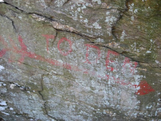
2008 photo
Or, perhaps, it’s still there and everyone – including me – has been missing it for a decade. I hiked all around this Nature Conservancy with my son Calvin in 2018 and then returned in 2019 in an attempt to find this particular Devil’s Den. I failed.
I did find some pictures from some gun nut forum as well as a brief description. This was from 2008.
I went back to devils den today…I crawled into the first room of the cave. To the left is a passage that is now blocked off by a collapsed rock. To the right is a tunnel with writing at the end of it and an arrow. I crawled to a point where I would have to crawl on my side between two rocks, and sadly I [wimped] out.
My grandfather says there are only two rooms left on the inside, the rest collapsed when they blasted for the road down below in the valley. There were more rooms and passages with an exit on the other side of the boulder.
Looking at these 2008 photos, with their faded paint, and reading about its collapsed rooms back then, I’m guessing it is just no longer accessible. Let me know if I’m wrong.
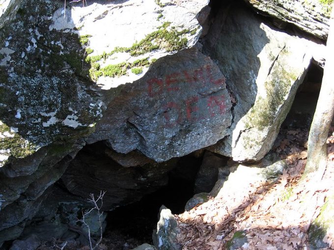
2008 photo
Rachel’s Hut
I really thought I’d find this one. And it never occurred to me that this story may be apocryphal. If I recall correctly, during our visit to the Ashbel Woodward House Museum, the docent there told me that the “hut” does indeed exist.
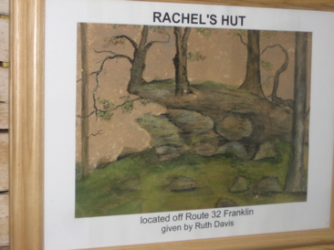
Here’s what I wrote back in 2010:
One cool thing here is painting by Dr. Woodward’s daughter-in-law, Mrs. Sarah Day Woodward. It shows two well known Franklin scenes (“well known” is a relative term, obviously). They are Rachel’s Hut and Giant’s Grave. Rachel’s Hut is apparently across the street and up the hill (if I were alone, I’d have gone off in search of it… And probably will someday). Rachel, a Native American woman, would come up from the Stonington area, build a lean-to shelter of saplings against a rock and spend the summer there gathering herbs and roots to take back to her tribe. She also earned a little money cleaning the Franklin Congregational Church.
And here we are in 2019 and I did half-heartedly search for it. I parked at the Woodward House museum/DEEP shooting range (weird, I know) and trudged up the (very) steep hill across route 32. It was very slow going through laurel and other mess.
I was forced to sidehill a lot and frankly, I gave up pretty quickly. After all, from the painting above it looks like a stinkin’ rock outcropping. We’ve all seen a million rock outcroppings. Who really cares about Rachel’s outcropping? I guess if you know exactly where it is and think it’s important for me to check it out let me know.
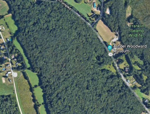
It’s supposedly in these woods. Somewhere.
Giant’s Grave
Yeah. I’ve got nothin’. But some guy named Miguel commented on the Asabel Woodward post referenced above with some convoluted hypothesis that takes the gravesite out of Franklin and into Norwich.
Which might as well be true. Who knows. Here’s the commenters comment:
We believe we have solved the mystery of the Giants Grave. A map of Norwich published in 1868 shows the area of the Giants Grave lies just south of Great Pine Swamp and an Indian Burying Ground. In 1643 the was a battle in the area between the Mohegan and the Narragansett Indians. The Mohegan were well prepared for the battle and successfully defended against the Narragansett Indians. They captured Miantonomoh, the nephew of the Narragansett grand sachem,Canonicus. The Mohegan boasted about the capture of the great Narragansett giant. Uncas, the Mohegan Sachem turn him over to the Connecticut authorities and was tried in Boston. He was found guilty and Uncas was given authority to kill him. Miantonomoh was taken back to Norwich, where he had been defeated, and killed with a tomahawk by Uncas brother Wawequa. Since the Giants Grave lies by a Indian Burying Ground I think its likely that it pertains to Miantonomoh grave.
Okay then.
![]()
Cushman Farms Trail
This one bothers me. I really wanted to find and hike this trail in 2019. I searched around quite a bit, while trying not to draw too much attention from the fine farmers at Cushman Farms.
I visited the farm in 2010 with Hoang and Damian and had a great time. It’s a Farmers Cow farm which means free ice cream at certain events. While my family ate, I poked around and came upon this sign:
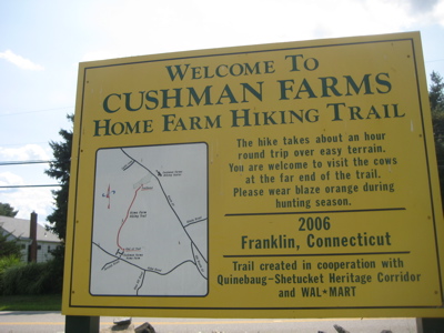
Granted, that sign was created 13 years prior to my 2019 visit, but c’mon! Farm trails should last! Perhaps it’s still there, but I certainly didn’t see the sign. I drove to both ends – the roads out here are pretty great to drive, by the way. Franklin offers a mix of farm and woods and the roads often transition between the two different scenes multiple times… anyway, I drove around and looked and checked around the two Cushman Farm facilities and… nothing.
Another Franklin Fail that I hope is a result of my ignorance and someone can help me out.
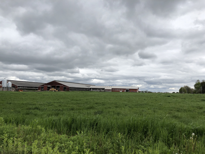
Cushman Farms
All things Satan in Connecticut
CTMQ’s Caves & Dens
 Eric G says
June 10, 2019 at 7:39 amHey man,
Devil’s den is very much still accessable but you’re looking in the wrong place. It is actually across the street from Ayers Gap, a little ways down Under The Mountain Rd and off to the side. I took my son there just yesterday on 6/9/2019 and took a few pictures. Indeed it has one main cavern, and a second one that you can get to if you squeeze. The other pathways have caved in (have been for as long as I remember)
Feel free to email me with any questions or if you need better directions!
 Suzanne says
February 1, 2020 at 9:45 amEric G, I would like better directions. I know it is off Under the Mountain Road and it is on the side with the water hole that used to have a rope swing (about 50 years ago). But I was just wondering if you could provide a few more details to put me a little closer to the right path.
 Matt Novosad says
December 16, 2023 at 2:27 pmHI there! I’m the Town Historian for Franklin.
I’ll be honest, these are some of my least favorite/interesting things to talk about because a lot of it is myth (at least the stories behind them) and frankly they’re not nearly as interesting as the actual people who lived and breathed and did things in this town. But c’est la vie!
Dragon’s Den exists and someone already mentioned that so I’ll skip it and speak on the other three.
Rachel’s Hut exists and you were in the right spot, although its on a confluence of private and state property. There is a trail, but it again crosses over different property boundaries and isn’t publicly accessible. It’s as you said, a rock outcropping. Whether or not the “Rachel” of the story is real is more than legend is the real issue. I have severe doubts about the traditional tale (which would also likely make Rachel a member of the Pequot tribe). Earlier on in the settlement’s history (so ~1663-1750s) there were Enslaved indigenous women in Norwich. In the Franklin records, James Caulkins was paid in for “keeping” an elderly Indigenous woman, that is, taking care of her as she was likely impoverished. I have a feeling this unnamed Native woman is the “Rachel” of legend and I don’t think she led as charmed of a life as the legend portrays and her hut is, as you point out, really just a rock outcropping.
The other is Giant’s Grave. It’s about .3 miles north of what was, at least for a time, called “Smith’s Corner” where Baltic Road and Route 32 meet. It’s pretty clear looking at topographical maps that the spot got the name “Giant’s Grave” because you’re effectively surrounded by hills on all sides. Turkey Hill to your immediate south, Meetinghouse Hill to your west, Hearthstone Hill to the east, and to the north lies Franklin and Pleasure Hills.
The hypothesis, as you state, from Miguel is preposterous. The “Indian Burying Ground” he mentions is from a centuries long game of telephone and refers to a small graveyard in Franklin of four graves that was originally known as the INLAND Burying Ground because it was inland from the rest of Norwich. By the 1800s it became known as the “Indian Burying Ground”, a clear corruption of “Inland”. Only four English settlers are buried there. The name of Giant’s Grave has nothing to do with Miantonomoh.
As for the Cushman Trail, you could always just ask the farm about their trail. It is bizarre that it seems to have disappeared.
There’s far more interesting parts of town history and I really wish that my forebears in this role would have done a better job talking about all of the other, interesting stuff, than just repeating the same old myths and stories.
Anyway, I hope this comment is of at least some help/consolation.
 Timothy says
June 3, 2024 at 12:24 pmIt took me quite a few trips to find the den, and I ended up finding it when I wasn’t even looking for it. There’s a trail on the west side of Under the Mountain Road about half a mile from Ayers gap. Head down this trail for 800 ft until you start to see a very steep hill in front of you. Before you get to the hill, turn right and head into the woods. You should cross over the end of a small stream. Keep going up the hill, keeping the stream to the left of you, and you should be able to find the den at the top.